|
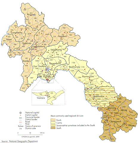
Territorial
Organization
This
territorial organization highlights the meridian
structure
of the buffer state formed by Lao PDR,
which
favors
relations to the west with Thailand and to the east
with
Vietnam, all the way along the respective 1,835 km
(1,500
km of which are constituted by the Mekong) and
2,060
km of common borders. There are also transverse
sections
along this stretch, in the form of three unofficial
regions:
the North, comprising the seven provinces located
north-west
of a line that goes from Huaphanh
to Xayabury;
the Centre,
which includes the seven provinces lying between this
line and Savannakhet;
and the South, which
covers
the four southern provinces. This division
reproduces
the three founding territories of Lan
Xang,
which
became separate kingdoms in the 18th century:
Luangphrabang,
Vientiane and Champassack (M.
Stuart-
Fox
1997, p. 17). These regions are now highly unequal,
with
the Centre containing half the population, the North
a
third and the South a fifth. The province of Savannakhet
is sometimes
attached to
the South
to reduce
this
imbalance.
This atlas hopes to contribute to the design of
new regional
divisions, better suited to the needs of
economic and
social development.
The
configuration of a buffer state and
territorial management
The
importance of
Laos
in continental
South-East Asia
stems
mainly from its political function as an intermediate space in the
heart of the peninsula. This position has preserved
it over the centuries, despite a frequently unfavorable
balance of power with its neighbors, first
to the
north and south, then to the west and east. Until the 14thcentury, the
Lao principalities separated the successive kingdoms
in
Yunnan
from those centered on
the
Mekong Delta.
Subsequently, the founding of Lan
Xang
established an
intermediate space between the Burmese and Siamese kingdoms on one
side, and the Viet
on the other. The political
split between Communist and free-market systems in
the peninsula cut through the middle of Laotian territory during
the war years, at the time of the meridian partition between
the zone controlled by the royal government in
Vientiane
and the zone controlled
by the Pathet
Lao in
Xamneua.
This fault line established itself on the
Mekong
,
from the time of the country's reunification
in 1975 until
Vietnam
,
Laos
,
Myanmar
and
Cambodia
joined
Thailand
as
members of ASEAN.
This
difficult process of nation-building left Lao
PDR
with two legacies. First, the country had to repair the
damage done by the war, which had displaced a quarter of
the 1973 population (730,000 people) within national
borders and caused 12% of the 1986 population (414,000
people) to leave the country. Between 1975 and 1979, the
return of 550,000 people to their provinces of origin was organized,
despite transport difficulties (C.
TaiUard,
1989).
Mine clearance in the territories bordering the roads of the
ormer controlled zone of Xamneua will need to continue for any years to make all the farming areas accessible again.
Because of its meridian structure, Lao PDR soon discarded the centralized
model of territorial management
adopted in 1975, as the Siamese and the French had been
obliged to do in the past. Indeed, from as early as the 16th
century, Fa
Ngum,
after having reunited the Laoprincipalities, organized
Lan Xang into three entities, with
the royal territory in Luangphrabang
extended south by
two successive territories in the
Mekong
Valley. On their
own scale, these three territories reproduced the concentric
spatial model marked by diminishing integration from the
core
to the periphery, characteristic of Thai political
systems. Lao PDR
has also sought to achieve the delicate
balance
that existed between these three territories in the
past, and which today governs relations between the
central government
and the provinces, and between the
provincial administrations and the districts.
Since 1975, the territorial organisation of Lao PDR
has been redrawn, with the number of provinces increased
from 13 to 18.
Vientiane
province, where 20% of the
country's population was located, was divided into three.
Luangnamtha
and Saravane
provinces were split into two
because of difficulties travelling between the
Mekong
Valley and the mountainous hinterland. The special zone
of Xaysomboun,
located between Xiengkhuang
and Vientiane
, was also created. Together with Bokeo
province
in the northern economic development quadrangle—
between
Laos
,
Myanmar
,
Thailand
and
China
's
Yunnan
province—studied by the Asian Development Bank
(ADB),
and Sekong
province east of the Bolovens
Plateau,
Xaysomboun is a strategic region for development.
Four types of provincial territories can be
distinguished in the current administrative organization.
The provinces in the Center, the narrowest part of the country, combine a range of natural landscapes and ethnic
structures from the
Mekong
to the Annamese
Cordillera.
These provinces are highly heterogeneous and open to both
Thailand
and
Vietnam
. The provinces of the second type
are bordered by the
Mekong
and
Thailand
. These become
increasingly homogeneous as they move from Bokeo to
Vientiane
municipality. There is also Champassack
province, which includes both banks of the
Mekong
and borders
Thailand
and
Cambodia
. The provinces of the third
type are located along the land borders and are open to
either two countries—Luangnamtha (Myanmar
and
China)
and Phongsaly
(China
and
Vietnam)—or
one—Huaphanh
(
Vietnam
). Sekong and Attapeu
provinces are isolated, despite the old network of the Ho Chi
Minh
Trail. The provinces of the fourth type are in an intermediate position
between the river and mountainous border provinces of the North. They are ecologically more homogeneous, with the Nam Beng
basin in Oudomxay,
a river junction in Luang phrabang (Nam
Ou, Xuang
and Khan), and a plateau in
Xiengkhuang.
|