|
Relief and
settlement
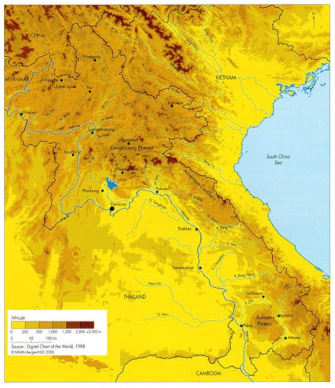
Northern
Laos, the most mountainous region, echoes the
pattern
of the Yunnan
fan some 500 km further south. The
tributaries
of the Mekong follow a NE-SW
direction,
recalling
that of the upper Irrawadi
River, while the Nam
Ma follows a NW-SE
direction, like the eastern basin of
the
Red River. Only the Xiengkhuang
Plateau,
with the
Plain
of Jars at its center, disrupts this fan pattern.
Like an
umbrella
radiating in all directions, it binds northern Laos
to
the Annamese
Cordillera. The cordillera
separates the
Mekong
Valley from the coastal plains of Central Vietnam
and
provides the junction with the Bolovens
Plateau, an
extension
of the Vietnamese plateaux.
The Mekong Valley is undergoing abrupt changes
of
direction in relation to its general meridian orientation,
between
Huoixai
and Luangphrabang
in the North, and
between
Xanakham
and Pakxanh
in the region of
Vientiane.
Beginning as a narrow corridor in the north, the
valley
then broadens into a series of plains between
Vientiane
and Thakhek,
although these are less expansive
than
those on the Thai bank. The Laotian plains broaden out
in
the region of Savannakhet,
before being hemmed in
again
in by the southern plateau. The differences in relief
between
the plains along the Mekong disrupt navigation.
Transport
is notably restricted by the rapids of Khemmarat,
south
of Savannakhet, and blocked altogether by the Khone
Falls
at the Cambodian
border.
The
population
density map
shows the
discontinuity
of settlement on the three main plains along
the
river: Vientiane, Savannakhet and Champassack.
Settlement
by the Lao ethnic group exceeds 50% almost
continuously
from Xayabury
to the south. It surpasses
87%
from Paklai
to Vientiane, and from the districts
bordering
Saravane
province to the Cambodian border.
The
proportion of Lao is just over 18% in the highlands
between
Xamneua
and Vientiane and in Khammouane
province
in the Center, creating a break between the
Austro-Asiatics
of the North and South.
|