|
Road
network and accessibility
Laos
is a mountainous country where
elevations of below
200
m
account for only 16% of the total area. More than 20
years
after reunification,
territorial and
economic
integration
is seriously hampered by the difficulty of
traveling
within the country. Travel is particularly arduous
during
the wet season because of poorly constructed and
poorly
maintained roads.
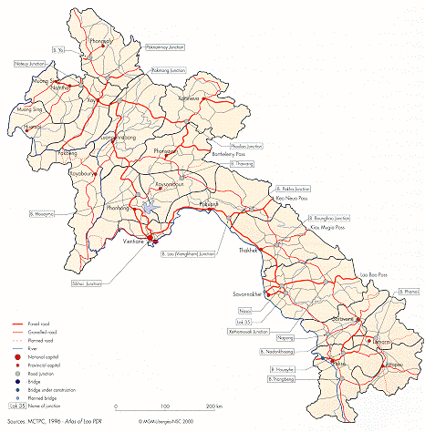
Road 13, between Namtha
on the Chinese border
and
Kinak
on the Cambodian
border, is the only meridian
axis
usable all year round, even though the section south of
Savannakhet
has not yet been paved. It links the capital
Vientiane
(population: 233,000) to Luangphrabang
in the
North
(population: 31,800), and to Thakhek
(population:
25,800),
Savannakhet (population: 62,200) and Pakse
(population:
47,600) in the South. It also services Namtha
(population:
14,400) and Muong
Xay
(population: 15,000)
in
the North. It is connected to the Thai network by a bridge
in
Vientiane
; another bridge is under
construction in Pakse.
The
second main road.
Road 1, runs east of Road 13 and
parallel
to it, across the Xiengkhuang
Plateau,
through the
interior
of the provinces of the Centre, the
Sekong
Valleyand
Attapeu.
It handles interprovincial
traffic. During the
war
years, this road linked the southern provinces on the
border
with
Vietnam
to Xamneua
in the zone controlled by
the
Neo
Lao Haksat.
Located west of the Ho Chi
Minh
Trail,
it
also suffered from bombing.
During the same period, the main transverse road in
the
North, linking Muong Sing to Xamneua, had a similar
strategic
role connecting the border provinces of the North.
The
Chinese-built road that follows the Nam
Beng
Valley
joined
up with the
Mekong
at Pakbeng,
but was not
extended
to
Thailand
. There is no direct road link
between
the
Xiengkhuang Plateau and
Vientiane
. In the Center,
Roads
8 and 9 link up with central
Vietnam
, via the
mountain
passes of Keo
Neua
and Lao Bao
(the lowest in
the
cordillera,
elevation 420 m). A third bridge planned at
Savannakhet,
with Japanese financing, as part of the
East-West
Corridor highway project studied by the ADB,
will
give prominence to Road 9.
|

