|
The Lao
People's Democratic Republic (Lao PDR)
is the
least
populous country in the Indochina Peninsula. The
1995
census recorded a population of 4,575,000, which is
just under
half that of Cambodia (9.8 million), and
between
10-6% of that of Myanmar
(46.5 million),
Thailand
(59.4 million) and Vietnam (75.5 million). Its
total
area of 236,800 km2
makes it the second-smallest
country,
between Cambodia (181,000 km2)
and Vietnam (330,400
km2), and a
long way behind Thailand (513,100 km2)
and Myanmar (676,600 km2).
Like Myanmar and
Thailand,
Laos is located in a river basin. However, unlike
the
basin in those countries, the Mekong Basin is shared
by
six countries, with Laos occupying 26%, China and
Myanmar
22% together, Thailand 23%, Cambodia 20%
and
Vietnam 9%.
A
multi-ethnic state with a territory off-center
from
the Mekong
The
dominant ethnic group accounts for a much smaller
proportion
of the population in Laos than in the
neighboring
countries. In the 1995 census, the Lao
made
up only 52% of the population. With the other
related
ethnic groups, the Tai-Kadai ethnolinguistic
family
constitutes two-thirds of the population, which is
slightly
less than the 69% generally attributed to the
Burmans
in yanmar. This is far below the domination
of
the Tai-Kadai family in Thailand (estimated at 83%),
the
Mon-Khmer in
Cambodia (87%)
and the
Vietnamese/Kinh
in Vietnam (87% in the 1989 census).
Each
of these dominant ethnic groups created its own
state
after a "march south". The Lao, following the
Mekong,
settled in the valleys of the river and its
tributaries,
where they practiced wet rice cultivation, pushing
the Austro-Asiatic
indigenous people towards
the
slopes, whence they derived their respective names of
Lao Loum (Lao of
the lowlands) and Lao Theung
(Lao of
the
slopes). This fragmented river space
and pronounced
multi-ethnic
structure can be explained by the relatively
late
timing of the Lao's "march south". The capital of the
kingdom ofLan Xang
was moved from Luangphrabang
to
Vientiane
in 1553, and the southward movement halted
there.
The Thai shifted their capital from Chieng Mai
to
Sukothai and reached
Ayuthaya, at the
head of the Chao
Praya delta, in 1350. They took over the declining Khmer
empire
in 1431 and blocked the Lao's access to the
Mekong
Delta. Deprived of a delta base for rice
cultivation
and of access to international maritime trade
essential
for building a nation of size, the Lao were unable
to
rival their neighbours (Christian Taillard,
1989).
The unequal balance of power with the kingdom
of Siam
manifested itself in the 19th century with the loss
of
the territories on the right bank of the Mekong, which
today
make up north-eastern Thailand and which include
the
broadest plains of the middle river basin. And twice in
half
a century�in 1778 and 1828�the Lao peoples of the
left
bank were deported to the Siamese bank. As a result,
the
Lao in Lan Na,
the former kingdom of northern
Thailand,
and in Isan
in the north-east, estimated at
respectively
30% and 20% of the population of Thailand,
are
nine times more numerous than the 2.4 million Lao in
Lao PDR. The
arrival of new waves of Miao-Yao
and
Tibeto-Burman
immigrants in the 19th century further
reduced
the proportion of Lao. The latter groups settled on
the
mountain peaks, whence the term Lao Soung
(Lao of
the
summits) used to designate them.
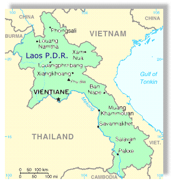
The nation's history explains why Laos is currently
the
most mountainous and most ethnically diverse country
in
the peninsula and why its territory is off center in
relation
to the Mekong. The width from east to west attains
500
km in the north of Lao PDR, but is only 150 km at
Thakhek
in the Center, accentuating the effects of
meridian
elongation (1,835 km by road and 1,865 km
along the Mekong) and
hampering territorial integration.
|